Introduction:
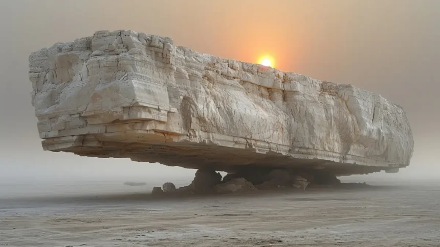
The Earth’s landscape is filled with breathtaking natural wonders, but some landforms are bizarre and unusual, capturing our imaginations with odd shapes and surreal beauty. From towering rock formations to vast salt flats that seem otherworldly, these strange creations of nature are a testament to our planet’s incredible diversity and unpredictability.
Read also: 10 Landmarks That Should Be Considered Wonders of the World
Have you ever wondered what it feels like to walk on a natural stone bridge or stand in a salt desert that mirrors the sky? These unique landscapes evoke a sense of wonder and leave us in awe of nature’s creative force.
This article will take you through the Top 10 Strangest Landforms worldwide. Whether you’re a geography enthusiast or simply curious about the planet’s oddities, these destinations should be on your travel bucket list!
1. Salar de Uyuni (Bolivia)
Overview: The world’s largest salt flat, spanning over 4,000 square miles, Salar de Uyuni is a vast, flat expanse in southwestern Bolivia. During the rainy season, the salt flat becomes a giant mirror, reflecting the sky and creating the illusion of endless horizons.
Read also: Discover the Dead Sea: 5 Surprising Health Benefits of This Salty Wonder
- Key Fact: Salar de Uyuni contains an estimated 10 billion tons of salt!
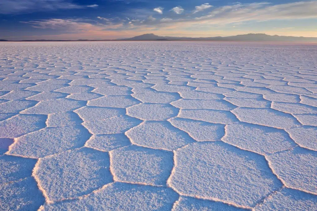
- Fun Fact: The reflective surface of the salt flat is so precise that it’s used to calibrate satellites.
- Why It’s Strange: Salar de Uyuni’s sheer size and mirror-like ability to reflect the sky makes it one of Earth’s most surreal landscapes and strangest landforms. Photographers flock to capture its otherworldly visuals during the wet season.
Read also: Freshwater vs. Saltwater: Do You Know 3 Most Important Distinctions?
2. The Wave (Arizona, USA)
Overview: Hidden in the remote Coyote Buttes North area of Arizona, The Wave is a stunning sandstone formation that resembles a frozen wave in mid-motion. Its swirling red, orange, and white bands appear otherworldly and one of the strangest landforms.
- Key Fact: The Wave is estimated to be around 190 million years old and was formed during the Jurassic period.
- Fun Fact: Due to its fragile ecosystem, only 20 permits are issued daily to visit The Wave, making it an exclusive destination for hikers.
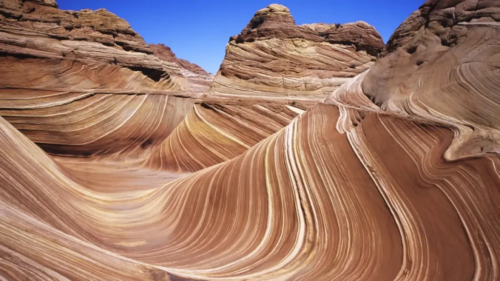
- Why It’s Strange: The unique wave-like shapes were formed by wind and water erosion, and the symmetrical formations look almost artificial. Its visually striking patterns give the impression of walking through a living painting.
3. Giant’s Causeway (Northern Ireland)
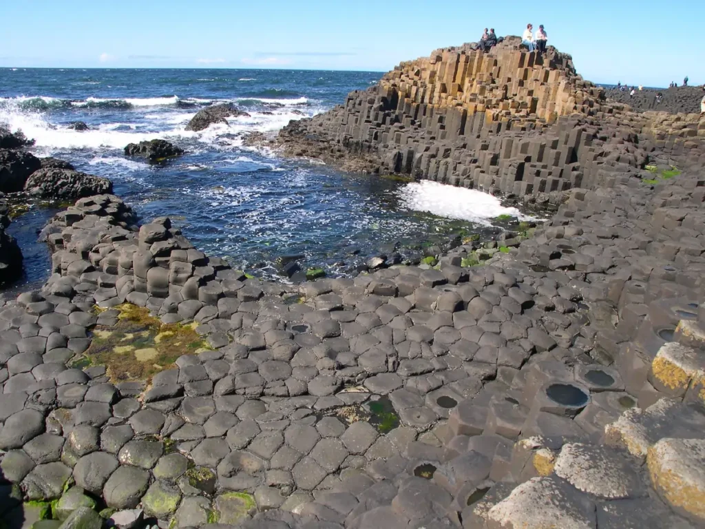
Overview: A UNESCO World Heritage Site, Giant’s Causeway consists of about 40,000 interlocking basalt columns that rise like stepping stones along the coast. These hexagonal columns were formed by volcanic activity around 60 million years ago.
- Key Fact: The tallest columns at Giant’s Causeway are 39 feet high.
- Fun Fact: According to legend, the giant Finn McCool built the causeway to cross the sea to Scotland.
- Why It’s Strange: The perfectly geometric shapes of the basalt columns make them look like an artificial structure, yet they are entirely natural. Their unique formation is both a geological marvel and a cultural symbol.
4. Zhangye Danxia Landform (China)
Overview: Known as the Rainbow Mountains, the Zhangye Danxia Landform is a spectacular display of multicolored rock layers in Gansu Province, China—vibrant red, yellow, and blue hues from mineral deposits layered over millions of years.
- Key Fact: The striking colors are caused by iron oxide and other minerals in the sandstone.
- Fun Fact: The colors of the mountains are even more vivid after rainfall, making the geological marvel like a painter’s palette.
- Why It’s Strange: It’s hard to believe such vibrant, natural color patterns exist without human intervention. The mountains look like a surreal painting come to life, making them one of the most colorful landscapes on Earth.
Read also: CHEMICAL WEATHERING: Nature’s Incredible Power to Transform Landscapes
5. Chocolate Hills (Bohol, Philippines)
Overview: The Chocolate Hills of Bohol, Philippines, are over 1,200 cone-shaped hills spread across 20 square miles. During the dry season, the hills turn a rich brown, resembling chocolate mounds, hence their name.
- Key Fact: The Chocolate Hills are made of limestone covered with grass, which turns brown in the dry season.
- Fun Fact: During the wet season, the hills are lush green, giving them a completely different appearance.
- Why It’s Strange: The uniformity of the hill shapes and their transformation from green to brown during different seasons make them one of the most unusual landscapes in the world.
Read also: Facts About Sedimentary Rocks: 7 Interesting Things You Never Knew About the Rocks Beneath You
| Landform | Location | Key Feature | Why It’s Strange |
|---|---|---|---|
| Salar de Uyuni | Bolivia | Largest salt flat, 4,000 sq miles | The reflective surface creates the illusion of endless horizons. |
| The Wave | Arizona, USA | Sandstone rock formation resembling a wave | The swirling, wave-like patterns look like modern art. |
| Why It’s Strange | Northern Ireland | 40,000 interlocking basalt columns | The near-perfect geometric shapes look man-made but are entirely natural. |
| Zhangye Danxia Landform | China | Rainbow-colored rock layers | The vibrant colors seem too beautiful to be real. |
| Chocolate Hills | Bohol, Philippines | Over 1,200 cone-shaped hills | The uniform cone shapes and seasonal color changes make these hills stand out. |
| Antelope Canyon | Arizona, USA | Narrow canyon with wave-like formations | The smooth, flowing rock formations and light beams create a surreal scene. |
| Bryce Canyon Hoodoos | Utah, USA | Tall, thin spires of rock | The large number of hoodoos gives the landscape an otherworldly appearance. |
| Eye of the Sahara | Mauritania | 25-mile-wide circular feature | Giant’s Causeway |
| Pamukkale Travertines | Turkey | White travertine terraces formed by hot springs | The snow-like appearance of the terraces contrasts with the warm blue pools. |
| Moeraki Boulders | New Zealand | Spherical boulders on a beach | The near-perfect roundness of the boulders makes them look like they were sculpted. |
6. Antelope Canyon (Arizona, USA)
Overview: Antelope Canyon is a spectacular slot canyon located in northern Arizona. Known for its narrow passageways and stunning wave-like rock formations, the canyon is particularly famous for the beams of light that shine through its openings, creating ethereal visuals.
Read also: Types of Rocks: 3 Processes that Shatter and Transform
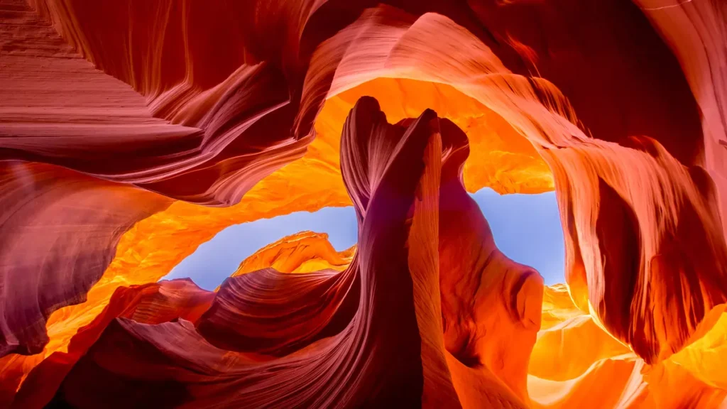
- Key Fact: The canyon was carved by the erosion of Navajo Sandstone over thousands of years, primarily by flash flooding.
- Fun Fact: Antelope Canyon is one of the most photographed slot canyons in the world due to how light interacts with its smooth, flowing rock walls.
- Why It’s Strange: The canyon’s sinuous curves and striking play of light give it an almost magical quality. Walking through the unusual landscape of Antelope Canyon feels like stepping into a natural art gallery.
7. Bryce Canyon Hoodoos (Utah, USA)
Overview: Bryce Canyon, located in southern Utah, is famous for its hoodoos—tall, thin spires of rock that protrude from the canyon basin. These rock formations were shaped by frost weathering and stream erosion over millions of years.
Read also: Physical Weathering: The Mechanical Breakdown of Rocks
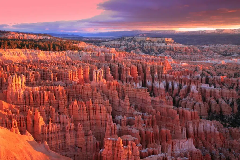
- Key Fact: The hoodoos in Bryce Canyon can reach 150 feet.
- Fun Fact: Hoodoos exist on every continent, but Bryce Canyon has one of the largest concentrations in the world.
- Why It’s Strange: The unusual, towering shapes of the hoodoos create a landscape that looks like it belongs on another planet, making it one of Earth’s most unique natural environments and strangest landforms.
8. Eye of the Sahara (Mauritania)
Overview: Also known as the Richat Structure, the Eye of the Sahara is a massive circular feature in the Sahara Desert, visible from space. This geological wonder is about 25 miles across and resembles a giant eye staring out of the desert.
- Key Fact: The Eye was once considered an impact crater, but geologists now believe a combination of uplift and erosion formed it.
- Fun Fact: The concentric rings of the Eye of the Sahara are so large that astronauts can see it clearly from space, earning it the nickname “Eye of Africa.”
- Why It’s Strange: The Eye of the Sahara’s perfectly circular rings and mysterious origins make it one of the most unusual landscapes on Earth.
Read also: How is the West Australian Desert Formed?
9. Pamukkale Travertines (Turkey)
Overview: Pamukkale, meaning “cotton castle” in Turkish, is a collection of white travertine terraces formed by hot spring deposits. The terraces look like frozen waterfalls cascading down a hillside, creating a magical landscape.
- Key Fact: Pamukkale’s hot springs have been used for therapeutic purposes for thousands of years, and ancient Romans built a spa city nearby.
- Fun Fact: Pamukkale, along with the nearby ancient city of Hierapolis, is a UNESCO World Heritage Site.
- Why It’s Strange: Pamukkale’s bright white terraces resemble snow, but they’re mineral deposits formed by hot water. The contrast between the terraces and the blue pools of water makes for a striking visual and geological marvel.
Read also: Don’t Miss These 5 Hidden Hot Springs: Your Secret to Ultimate Relaxation
10. Moeraki Boulders (New Zealand)
Overview: The Moeraki Boulders are large, spherical boulders scattered along a beach on New Zealand’s Otago coast. These boulders formed millions of years ago and are made of mudstone, cemented by calcium and carbonates.
- Key Fact: Some boulders are as large as 10 feet in diameter.
- Fun Fact: According to Māori legend, the boulders are the remains of calabashes and baskets that washed ashore after a mythical canoe wreck.
- Why It’s Strange: The boulders’ nearly perfect roundness makes them look like human hands shaped them, but these strangest landforms are entirely natural formations created by erosion over time.
Read also: Negative Effects of Climate Change on Indigenous People of the World
Key Takeaway
From salt flats that reflect the sky to perfectly round boulders scattered along a beach, these strangest landforms remind us how diverse and surprising the Earth can be. Each of these natural wonders has its own story, shaped by the forces of nature over millions of years. Whether you’re an avid traveler or simply curious about our planet, these landforms are a testament to Earth’s incredible ability to create the unexpected.
FAQs:
1. What causes landforms like The Wave?
The Wave was formed over millions of years by wind and water erosion acting on Navajo Sandstone, resulting in its distinctive wavy shapes.
2. How are the Moeraki Boulders so perfectly round?
The boulders formed by sediment accumulation around a core, a process called concretion, over millions of years, resulting in their spherical shapes.
3. Can you visit the Salar de Uyuni year-round?
Yes, but the best time to visit is during the rainy season (December to April), when the salt flats create a mirror effect reflecting the sky.
4. Are the colors of the Zhangye Danxia Landform natural?
Yes, the vivid colors are caused by the accumulation of minerals like iron and copper in the sandstone over millions of years.
5. What is the significance of the Eye of the Sahara?
The Eye of the Sahara, or Richat Structure, is believed to be a geological dome formed by erosion. Its size and shape make it visible from space.


